


Physical Map of Europe
Price range: £39.00 through £49.00
This physical map of Europe is a richly detailed poster showing the continent’s natural landscape in full. Rivers, mountain ranges, seas, coastlines and land cover types are all clearly mapped, from the tundra of northern Scandinavia to the deserts of North Africa. Printed in high quality on heavyweight paper, it is available in A2, A1 and A0 sizes to suit any space. Whether you are furnishing a home, a study or an office, this is a map that earns a second look every time you pass it.
Free UK shipping
- Satisfaction Guaranteed
- Printed on Demand
- Secure Payments
Physical Map of Europe
If you have ever wanted to understand Europe beyond its borders, this physical map of Europe gives you the full picture. It strips back the political lines and puts the natural world front and centre, revealing the continent as it actually is: shaped by mountain ranges, river systems, seas and plains that have defined civilisations for thousands of years.
What the Map Shows
This is not a simple outline map. The physical map of Europe is drawn using shaded relief and bathymetric detail, giving every mountain range and ocean basin a genuine sense of depth and dimension. The colour coding is clear and considered. Glacier white, tundra pale brown, northern forest deep green, temperate forest mid green, Mediterranean vegetation olive gold, wetland teal and desert sandy tan. Each land cover type is easy to read at a glance, and a full legend is included on the map face.
Major features shown include the Alps, the Pyrenees, the Carpathians, the Scandinavian Mountains and the Caucasus. The rivers Danube, Rhine, Volga, Elbe and many more are clearly labelled. Seas including the North Sea, Baltic Sea, Black Sea, Caspian Sea, Adriatic and the full extent of the Mediterranean are all named and positioned accurately.
Countries, coastlines and island groups such as the British Isles, Iceland, Corsica and Sardinia are all included. The map extends east into Russia and south into North Africa and the Middle East, giving proper geographic context to the European continent.
About the Print
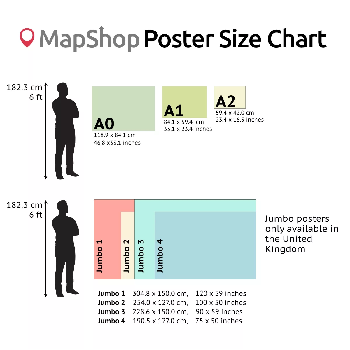
The physical map of Europe is available in three sizes: A2 (420 x 594mm), A1 (594 x 841mm) and A0 (841 x 1189mm). All sizes are printed on high-quality heavyweight poster paper, with clean, sharp colour reproduction that does the cartography justice.
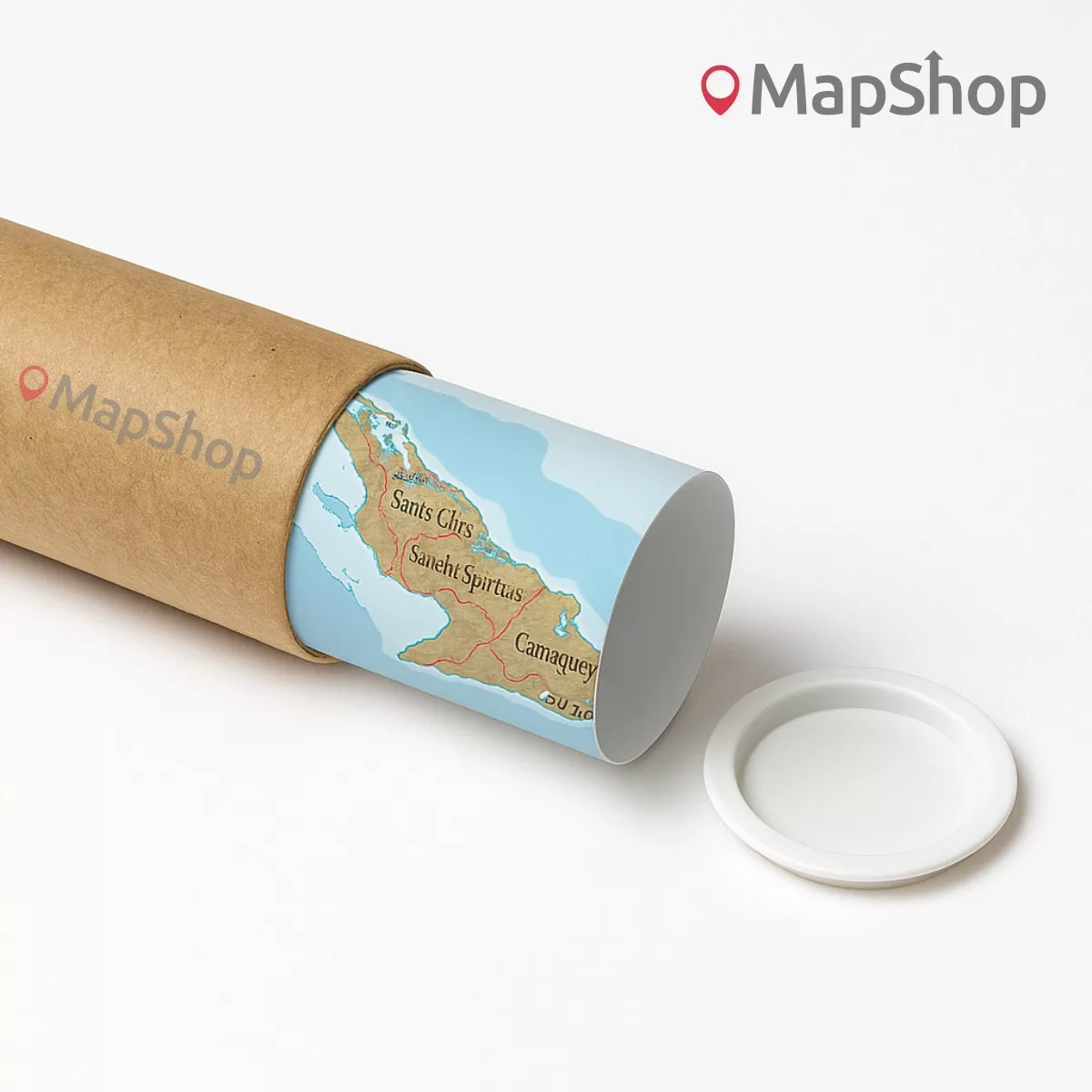
This is a print-only product. No frame is included. The map is sent rolled in a protective tube, ready to hang or mount to your preference.
Who It Is For
This physical map of Europe suits a wide range of buyers. Students and teachers will find it invaluable as a geography reference. Travellers and travel planners can use it to map out routes and understand the terrain. For home and office interiors, the natural tones and detailed artwork make it a genuine talking point on any wall. It also makes a thoughtful and practical gift for anyone with a curiosity about the world.
Order from MapShop and receive a beautifully printed physical map of Europe, shipped worldwide.
| Size | A2 – (594 x 420 mm) (23.4 x 16.5"), A1 – (841 x 594 mm) (33.1 x 23.4"), A0 – (1189 x 841 mm) (46.8 x 33.1") |
|---|
Related products

NATO Map
Price range: £29.00 through £49.00Select options This product has multiple variants. The options may be chosen on the product pagePeters Projection Map (Political-Simple)
Price range: £45.00 through £59.00Select options This product has multiple variants. The options may be chosen on the product pageOfficial TfL Night Tube Map & London Overground Map
Price range: £69.00 through £115.00Select options This product has multiple variants. The options may be chosen on the product page


 (simple)")


&url=https://map-shop.co.uk/product/peters-projection-map-political-simple/&media=https://map-shop.co.uk/wp-content/uploads/2024/10/ms00003-peters-map-simple-copyright.jpg)