


Peters Projection Map (Political-Simple)
Price range: £45.00 through £59.00
Last Updated: October 2024
Maps not only represent the world, they shape the way we see it. The revolutionary Peters Projection map presents countries in their true proportion to one another: it has been adopted by the UN, aid agencies, schools and businesses around the world.
Free UK shipping
- Satisfaction Guaranteed
- Printed on Demand
- Secure Payments
The Peters Projection Map of the world is an Equal Area cylindrical projection with standard parallels at 45 degrees thus resulting in a distortion of shape which is stretched about the equator and squashed towards the poles, but having the great advantage that all countries are correct in size in relation to each other. Widely used in educational and business circles as an icon of the modern concept of world equality.
This is a simple version of the standard Peters Map. For detailed version, please see Peters Projection Map (detailed).
This base is maintained by Oxford Cartographers, who originally drew the map and are an authorised seller.
Built to order
Our premium matte paper is heavier-weight, white, and features a smooth, uncoated finish that feels luxuriously soft to the touch:
- Paper Finishing: Matte, smooth, non-reflective surface.
- Paper Weight: 200 gsm (80 lb), thickness: 0.26 mm (10.3 mils).
- Sustainable Paper: FSC-certified or equivalent paper for sustainability.
Find out more about the Peters Map and other projections at the Peters Projection website.
Product notes:
Built to order for the highest quality finish.
The word “@COPYRIGHT” will not appear on your purchased map.
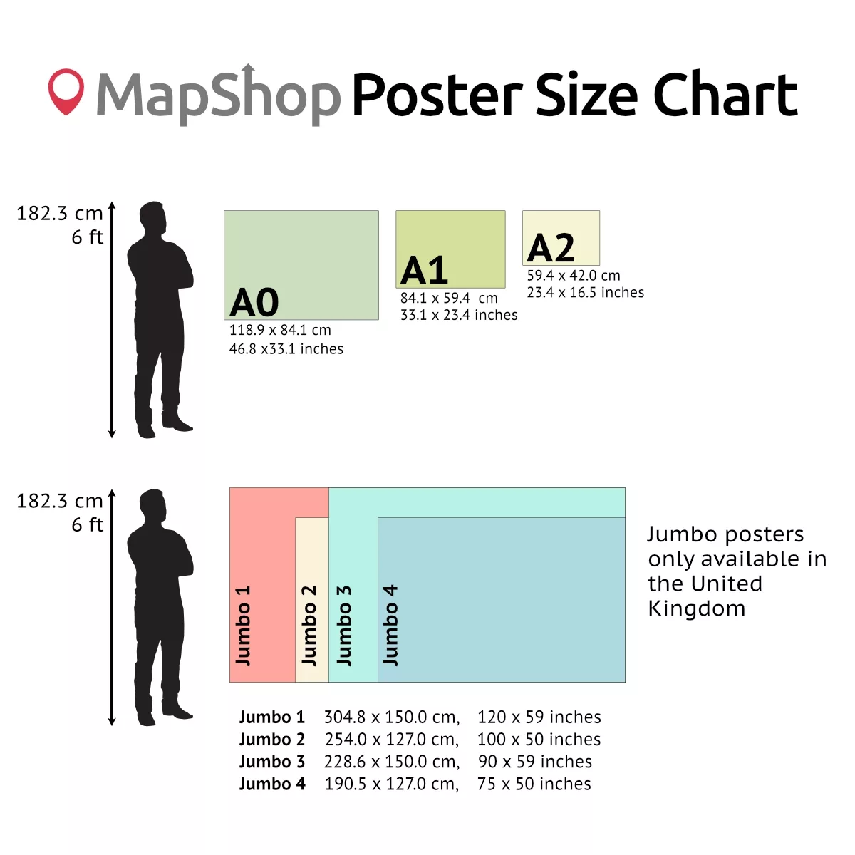
| Size | A2 – (594 x 420 mm) (23.4 x 16.5"), A1 – (841 x 594 mm) (33.1 x 23.4"), A0 – (1189 x 841 mm) (46.8 x 33.1") |
|---|
Only logged in customers who have purchased this product may leave a review.
You may also like…

Peters Equal Area World Map (Political-Detailed)
Price range: £45.00 through £59.00Select options This product has multiple variants. The options may be chosen on the product pagePeters Projection Map (Educational)
Price range: £45.00 through £59.00Select options This product has multiple variants. The options may be chosen on the product pagePeters Equal Area World Map (Environmental)
Price range: £45.00 through £59.00Select options This product has multiple variants. The options may be chosen on the product page


")
Related products
World Time Zones Map
Price range: £39.00 through £55.00Select options This product has multiple variants. The options may be chosen on the product pageModified Gall World Projection Map (Environmental-Simple)
Price range: £39.00 through £59.00Select options This product has multiple variants. The options may be chosen on the product pagePhysical Map of Europe
Price range: £39.00 through £49.00Select options This product has multiple variants. The options may be chosen on the product page


")

&url=https://map-shop.co.uk/product/peters-projection-map-political-simple/&media=https://map-shop.co.uk/wp-content/uploads/2024/10/ms00003-peters-map-simple-copyright.jpg)
&url=https://map-shop.co.uk/product/peters-equal-area-world-map-political/&media=https://map-shop.co.uk/wp-content/uploads/2024/10/ms00003-peters-map-political-copyright.jpg)
&url=https://map-shop.co.uk/product/peters-projection-map-educational/&media=https://map-shop.co.uk/wp-content/uploads/2024/11/ms00003-peters-map-edu-pol-copyright.jpg)
&url=https://map-shop.co.uk/product/peters-equal-area-world-map-env/&media=https://map-shop.co.uk/wp-content/uploads/2024/10/ms00004-peters-map-environmental-copyright.jpg)
&url=https://map-shop.co.uk/product/modified-gall-world-projection-map-environmental-simple/&media=https://map-shop.co.uk/wp-content/uploads/2025/01/ms00007-gall-map-env-simple-copyright-1024x724.jpg)
Reviews
There are no reviews yet.