


Peters Projection Map (Educational)
Price range: £45.00 through £59.00
Last Updated: October 2024
The Peters Projection Map, Educational version offers an explanation of why this projection is a world map designed to offer a more accurate representation of the sizes of land masses compared to previous maps.
This is the political version showing the different countries – there is also a topographical version available.
Free UK shipping
- Satisfaction Guaranteed
- Printed on Demand
- Secure Payments
Peters Projection Map – Political Edition (White Background)
Discover the Peters Projection Map of the World, a thought-provoking alternative to traditional world maps, designed to present a more accurate comparison of landmass sizes. Unlike the commonly used Mercator projection, the Peters projection represents countries in their true proportional size, offering a fairer view of the world.
This political edition clearly shows country borders in vibrant colours, making it ideal for educational use in classrooms, public spaces, or as a conversation-starting piece for the home or office. An educational version is available, providing background on the projection’s development and its significance, along with a topographical edition for those who prefer a focus on physical geography.
Map details and origins:
Produced and maintained by Oxford Cartographers, a trusted name in cartography.
We are an authorised UK seller, ensuring authenticity and premium quality.
Updated to reflect current political boundaries.
Paper and print quality:
Premium matte finish – smooth, non-reflective surface for easy viewing in all light conditions.
Heavyweight paper – 200 gsm (80 lb), thickness 0.26 mm (10.3 mils), giving a high-quality, durable feel.
Sustainably sourced – FSC-certified or equivalent, environmentally responsible paper.
Product notes:
Built to order for the highest quality finish.
The word “@COPYRIGHT” will not appear on your purchased map.
The Peters Projection Map isn’t just a piece of wall art – it’s a tool for learning and discussion, challenging perspectives on how we see the world and encouraging a more balanced global view. Find out more about the Peters Map and other projections at the Peters Projection website.
An environmental version of the Peters World Map is also available.
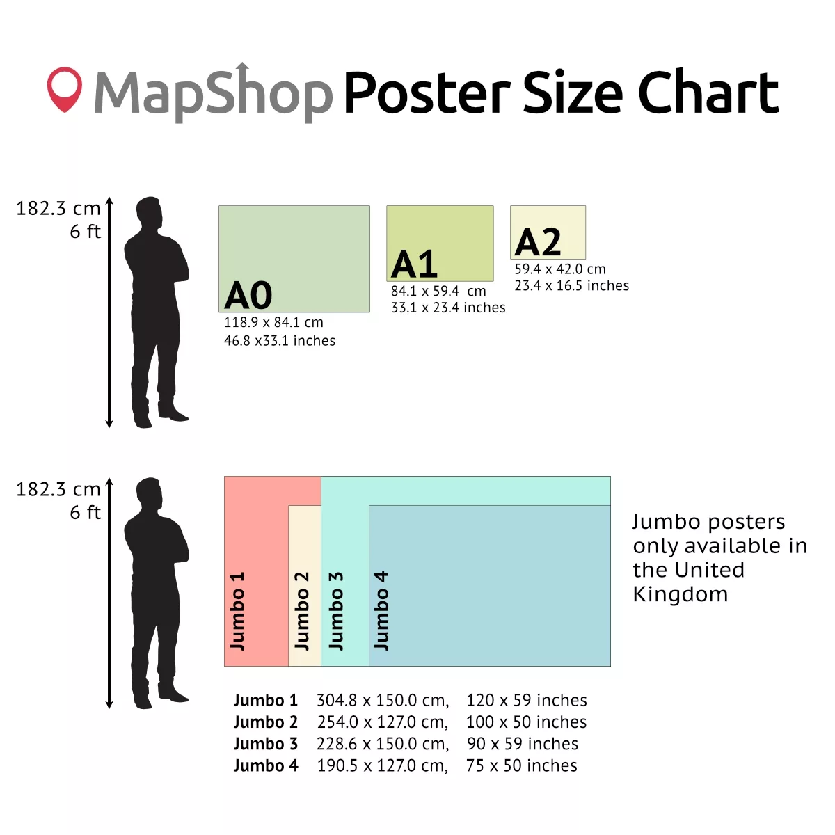
| Size | A2 – (594 x 420 mm) (23.4 x 16.5"), A1 – (841 x 594 mm) (33.1 x 23.4"), A0 – (1189 x 841 mm) (46.8 x 33.1") |
|---|
Only logged in customers who have purchased this product may leave a review.
You may also like…

Peters Equal Area World Map (Political-Detailed)
Price range: £45.00 through £59.00Select options This product has multiple variants. The options may be chosen on the product pagePeters Equal Area World Map (Environmental)
Price range: £45.00 through £59.00Select options This product has multiple variants. The options may be chosen on the product pagePeters Projection Map (Political-Simple)
Price range: £45.00 through £59.00Select options This product has multiple variants. The options may be chosen on the product page


")

 (simple)")
Related products
Equal Earth Wall Map (Physical)
Price range: £55.00 through £75.00Select options This product has multiple variants. The options may be chosen on the product pageEqual Earth Wall Map (Political)
Price range: £55.00 through £75.00Select options This product has multiple variants. The options may be chosen on the product pageHobo-Dyer Equal Area Maps (Traditional)
Price range: £39.00 through £59.00Select options This product has multiple variants. The options may be chosen on the product page


&url=https://map-shop.co.uk/product/peters-projection-map-educational/&media=https://map-shop.co.uk/wp-content/uploads/2024/11/ms00003-peters-map-edu-pol-copyright.jpg)
&url=https://map-shop.co.uk/product/peters-equal-area-world-map-political/&media=https://map-shop.co.uk/wp-content/uploads/2024/10/ms00003-peters-map-political-copyright.jpg)
&url=https://map-shop.co.uk/product/peters-equal-area-world-map-env/&media=https://map-shop.co.uk/wp-content/uploads/2024/10/ms00004-peters-map-environmental-copyright.jpg)
&url=https://map-shop.co.uk/product/peters-projection-map-political-simple/&media=https://map-shop.co.uk/wp-content/uploads/2024/10/ms00003-peters-map-simple-copyright.jpg)
&url=https://map-shop.co.uk/product/equal-earth-wall-map-physical/&media=https://map-shop.co.uk/wp-content/uploads/2025/11/ms01004-equal-earth-env-a0-2-1024x1024.webp)
&url=https://map-shop.co.uk/product/equal-earth-wall-map/&media=https://map-shop.co.uk/wp-content/uploads/2025/08/ms01004-equal-earth-1024x1024.jpg)
&url=https://map-shop.co.uk/product/hobo-dyer-equal-area-maps/&media=https://map-shop.co.uk/wp-content/uploads/2024/11/ms00005-hodo-dyer-en-spup-pacific-detailed-copyright-1024x701.jpg)
Reviews
There are no reviews yet.