Showing 1–16 of 18 results

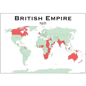
£29.00 – £49.00Price range: £29.00 through £49.00The British Empire Map is a detailed historical world map showing the extent of the British Empire in 1921. Ideal for education, study spaces and period interiors.
£35.00 – £49.00Price range: £35.00 through £49.00The Caribbean Map provides a detailed political and physical map of the Caribbean, clearly displaying countries, islands, and geographical features. Ideal for educational, professional, or decorative use.
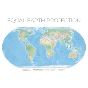
£55.00 – £75.00Price range: £55.00 through £75.00Discover the Equal Earth Wall Map: a visually stunning, true‑scale world map that corrects centuries‑old distortions, backed by the African Union for its powerful cultural and educational impact.
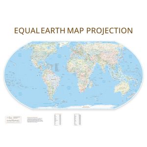
£55.00 – £75.00Price range: £55.00 through £75.00Discover the Equal Earth Wall Map: a visually stunning, true‑scale world map that corrects centuries‑old distortions, backed by the African Union for its powerful cultural and educational impact.
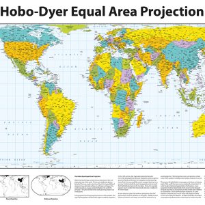
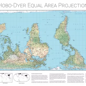
£39.00 – £59.00Price range: £39.00 through £59.00The Hobo-Dyer Equal-Area Maps, created to challenge traditional perspectives, accurately depict the relative sizes of countries and continents while questioning conventional North-South orientations. Developed by ODT, Inc., this projection builds on the Peters equal-area concept but is designed to reduce distortion in both the size and shape of landmasses, offering a more faithful representation than standard maps.
Commissioned in 2002 by Howard Bronstein (“Ho”) and Bob Abramms (“Bo”) of ODT, Inc., the map was skillfully drawn by Mick Dyer of Oxford Cartographers
Last updated by Oxford Cartographers: October 2024
£39.00 – £59.00Price range: £39.00 through £59.00The Hobo-Dyer Equal Area World Maps, (Modern Design) created to challenge traditional perspectives, accurately depict the relative sizes of countries and continents while questioning conventional North-South orientations. Developed by ODT, Inc., this projection builds on the Peters equal-area concept but is designed to reduce distortion in both the size and shape of landmasses, offering a more faithful representation than standard maps.
Skillfully drawn by Mick Dyer of Oxford Cartographers
Looking for a more traditional feel? See our classic version Hobo-Dyer Equal Area World Maps
Last updated by Oxford Cartographers: October 2024
£39.00 – £59.00Price range: £39.00 through £59.00The Hobo-Dyer Equal Area World Maps (Relief Version), created to challenge traditional perspectives, accurately depict the relative sizes of countries and continents while questioning conventional North-South orientations. Developed by ODT, Inc., this projection builds on the Peters equal-area concept but is designed to reduce distortion in both the size and shape of landmasses, offering a more faithful representation than standard maps.
Skillfully drawn by Mick Dyer of Oxford Cartographers
Looking for a more traditional feel? See our classic version Hobo-Dyer Equal Area World Maps
Last updated by Oxford Cartographers: January 2026
£39.00 – £59.00Price range: £39.00 through £59.00Last Updated: November 2024
The Modified Gall World Projection Map is a modified version of the original Gall map carried out by Oxford Cartographers.
Orientation: Landscape
Sizes Available: A0, A1, A2
£39.00 – £59.00Price range: £39.00 through £59.00Last Updated: November 2024
The Modified Gall World Projection Map is a modified version of the original Gall map carried out by Oxford Cartographers.
Orientation: Landscape
Sizes Available: A0, A1, A2
£39.00 – £59.00Price range: £39.00 through £59.00Last Updated: November 2024
The Modified Gall World Projection Map is a modified version of the original Gall map carried out by Oxford Cartographers.
Orientation: Landscape
Sizes Available: A0, A1, A2
£45.00 – £59.00Price range: £45.00 through £59.00Peters Equal Area World Map – Updated October 2024
Maps not only represent the world, they shape the way we see it. The revolutionary Peters Projection map presents countries in their true proportion to one another: it has been adopted by the UN, aid agencies, schools and businesses around the world.
£45.00 – £59.00Price range: £45.00 through £59.00Last Updated: October 2024
Maps not only represent the world, they shape the way we see it. The revolutionary Peters Equal Area World Map presents countries in their true proportion to one another: it has been adopted by the UN, aid agencies, schools and businesses around the world.
£45.00 – £59.00Price range: £45.00 through £59.00Last Updated: October 2024
The Peters Projection Map, Educational version offers an explanation of why this projection is a world map designed to offer a more accurate representation of the sizes of land masses compared to previous maps.
This is the political version showing the different countries – there is also a topographical version available.
£45.00 – £59.00Price range: £45.00 through £59.00Last Updated: October 2024
Maps not only represent the world, they shape the way we see it. The revolutionary Peters Projection map presents countries in their true proportion to one another: it has been adopted by the UN, aid agencies, schools and businesses around the world.
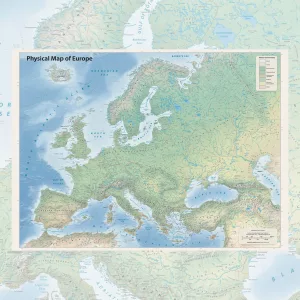
£39.00 – £49.00Price range: £39.00 through £49.00This physical map of Europe is a richly detailed poster showing the continent’s natural landscape in full. Rivers, mountain ranges, seas, coastlines and land cover types are all clearly mapped, from the tundra of northern Scandinavia to the deserts of North Africa. Printed in high quality on heavyweight paper, it is available in A2, A1 and A0 sizes to suit any space. Whether you are furnishing a home, a study or an office, this is a map that earns a second look every time you pass it.
£39.00 – £55.00Price range: £39.00 through £55.00Plan globally with confidence using this beautifully detailed Standard Time Zones Map of the World map poster. Ideal for offices, classrooms, travel agencies or anyone managing international schedules.


")

")


")

")


 (simple)")


&url=https://map-shop.co.uk/product/equal-earth-wall-map-physical/&media=https://map-shop.co.uk/wp-content/uploads/2025/11/ms01004-equal-earth-env-a0-2-1024x1024.webp)
&url=https://map-shop.co.uk/product/equal-earth-wall-map/&media=https://map-shop.co.uk/wp-content/uploads/2025/08/ms01004-equal-earth-1024x1024.jpg)
&url=https://map-shop.co.uk/product/hobo-dyer-equal-area-maps/&media=https://map-shop.co.uk/wp-content/uploads/2024/11/ms00005-hodo-dyer-en-spup-pacific-detailed-copyright-1024x701.jpg)
&url=https://map-shop.co.uk/product/hobo-dyer-equal-area-world-maps/&media=https://map-shop.co.uk/wp-content/uploads/2025/08/ms00008-hobo-dyer-en-npup-africa-detailed-1024x701.jpg)
&url=https://map-shop.co.uk/product/hobo-dyer-equal-area-world-maps-relief-version/&media=https://map-shop.co.uk/wp-content/uploads/2026/01/ms00009-hobo-dyer-relief-en-npup-modern-full-1024x724.webp)
&url=https://map-shop.co.uk/product/modified-gall-world-projection-map-environmental-simple/&media=https://map-shop.co.uk/wp-content/uploads/2025/01/ms00007-gall-map-env-simple-copyright-1024x724.jpg)
&url=https://map-shop.co.uk/product/modified-gall-world-projection-map-political-detailed/&media=https://map-shop.co.uk/wp-content/uploads/2025/01/ms00007-gall-map-pol-detailed-copyright-1024x724.webp)
&url=https://map-shop.co.uk/product/modified-gall-world-projection-map-political-simple/&media=https://map-shop.co.uk/wp-content/uploads/2025/01/ms00007-gall-map-pol-simple-copyright-1024x724.jpg)
&url=https://map-shop.co.uk/product/peters-equal-area-world-map-env/&media=https://map-shop.co.uk/wp-content/uploads/2024/10/ms00004-peters-map-environmental-copyright.jpg)
&url=https://map-shop.co.uk/product/peters-equal-area-world-map-political/&media=https://map-shop.co.uk/wp-content/uploads/2024/10/ms00003-peters-map-political-copyright.jpg)
&url=https://map-shop.co.uk/product/peters-projection-map-educational/&media=https://map-shop.co.uk/wp-content/uploads/2024/11/ms00003-peters-map-edu-pol-copyright.jpg)
&url=https://map-shop.co.uk/product/peters-projection-map-political-simple/&media=https://map-shop.co.uk/wp-content/uploads/2024/10/ms00003-peters-map-simple-copyright.jpg)