Discover our range of UK rail maps showing the national rail network and key regional routes across England, Scotland and Wales. From comprehensive UK railway network maps to officially licensed Transport for London rail and Tube services maps, each design presents complex rail information clearly and accurately.
Designed for clarity and ease of use, these maps make it simple to understand routes, connections and coverage across Britain’s rail system. They are ideal for homes, offices, classrooms and professional environments where reliable, easy-to-read mapping is essential.
All maps are produced or curated by professional cartographers and printed in the UK using high-quality materials. Available in a range of sizes, they offer an authoritative and up-to-date view of the UK rail network for both practical reference and display.
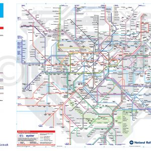
The TfL London’s Rail & Tube Services Map, or London Underground map, is one of the most famous maps in the world and seen as a symbol of London. We provide a range or larger sizes as well as wallpaper and vinyl, which can be used to add an iconic piece of transport history to any bedroom or living space.
Select options This product has multiple variants. The options may be chosen on the product page
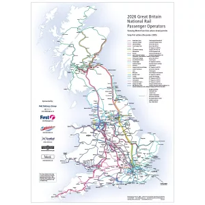
The UK Railway Network Map – Explore every UK train operator and tram network with the official 2026 National Rail Map – 62nd Edition. Essential for travellers, planners and rail enthusiasts. Updated April 2026.
Select options This product has multiple variants. The options may be chosen on the product page
The framed UK Railway Network Map – Explore every UK train operator and tram network with the official 2026 National Rail Map – 62nd Edition. Essential for travellers, planners and rail enthusiasts. Updated April 2026.
Select options This product has multiple variants. The options may be chosen on the product page
Explore the UK train network with this clear, easy-to-read map showing principal train routes, key stations, airport interchanges and ferry services. Looking for more detailed network map, view the UK Train Network Map.
Full UK Train Network Map 2026
Select options This product has multiple variants. The options may be chosen on the product page


")

&url=https://map-shop.co.uk/product/uk-railway-network-map-2026-framed/&media=https://map-shop.co.uk/wp-content/uploads/2026/04/ms01005-bd-uk-railway-map-framed-1024x1024.webp)
&url=https://map-shop.co.uk/product/uk-railway-network-map-colour/&media=https://map-shop.co.uk/wp-content/uploads/2024/11/ms00004-uk-rail-map-a0-cmyk-726x1024.png)